ERC grant helps to apply geoinformatics to mitigate the environmental impact of intensive agriculture

The European Research Council (ERC) has awarded Evelyn Uuemaa, Professor of Geoinformatics at the University of Tartu, the Consolidator Grant to develop models based on remote sensing data and machine learning that will enable both farmers and policymakers to plan nature-based solutions in the landscape to mitigate the negative environmental impact of intensive agriculture.
The rapid growth of the world's population has increased the demand for intensive agriculture. Unfortunately, this often comes with negative environmental impacts. This is why more and more people are looking for new ways of sustainable agriculture, where the environmental impact is reduced as yields increase. Nature-based solutions, such as wetlands and riparian buffer strips along watercourses, can effectively reduce nutrient (nitrogen and phosphorus) runoff from agricultural catchments. However, it is neither economically viable nor, in most cases, naturally feasible to establish them throughout the landscape. It is therefore important to identify priority areas in the landscape when planning nature-based solutions, making smart use of spatial data.
The team of Evelyn Uuemaa, Professor of Geoinformatics at the University of Tartu, uses geoinformatics methods to test existing spatial data processing solutions and create new ones. According to Uuemaa, the amount of spatial data from satellites has exploded in the last 10–15 years. "Yet this is largely an untapped resource, as the spatial data processing capabilities and the machine learning skills that can be applied to them have not caught up with the large volumes of data. So, this data has largely remained unused in decision-making processes," explained Uuemaa.
The amount of spatial data from satellites has exploded in the last 10–15 years. Yet this is largely an untapped resource, as the spatial data processing capabilities and the machine learning skills that can be applied to them have not caught up with the large volumes of data. So, this data has largely remained unused in decision-making processes.
In the upcoming project, Uuemaa's team plans to use spatial data (including remote sensing) to identify critical nutrient runoff hotspots on the one hand, and the most suitable sites for establishing and restoring wetlands and riparian buffer strips on the other.
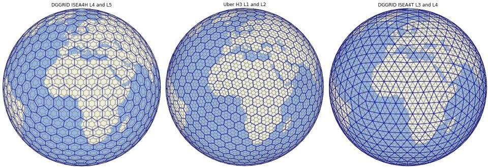
Using spatial data from different sources creates the need to bring them into the same coordinate system and reach the same spatial resolution. This becomes particularly important when using machine learning. "The complexity of the task stems from the fact that the Earth is spherical, but our data models are mostly planar. This automatically means distortions in the initial information," said Uuemaa. To avoid distortions, the development of new unique coordinate systems has started to cover the entire globe with a uniform discrete global grid (see figure). This is a hierarchical grid, in which each cell is individually identifiable.
Uuemaa's research team has been working for several years on indexing and connecting such a grid more efficiently. "In the upcoming research project, we can develop the best solution for linking environmental data to a data cube based on the discrete global grid, which allows data to be analysed from the global to the local level without changing the coordinate system," she explained. It is also very well suited for machine learning applications. The team will use machine learning in modelling to identify hotspots of agricultural diffuse pollution. "The European Space Agency and the European statistical offices are also interested in such a data cube solution, as it allows very large spatial data to be taken to a unified format and used more efficiently," said Uuemaa.
The project will result in global map layers that will allow the identification of critical nutrient runoff sites and carry out the related planning. All the analysis will take place on a global scale, and the results will be tested on pilot sites in Europe and beyond. The project will be based on open-source software, so that the resulting data cube solution and machine learning models will be accessible and available for further development by all.
The ERC grant amounts to nearly €2 million and is intended to support the further development of an established researcher. The research project will run for five years, and its implementation will involve creating two post-doctoral fellowships, three doctoral student places and one position of a scientific programmer.